HYDRODYNAMICS 2023
Numerical Modeling of Jacksonville Harbor Deepening Project, Florida
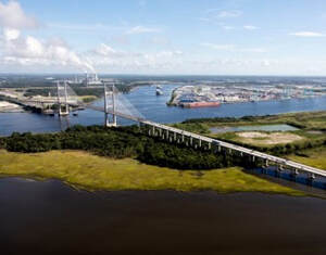
Dynamic Solutions developed a cutting-edge 3-D hydrodynamic model Jacksonville Harbor to evaluate the impacts of channel deepening on salinity intrusion for the USACE Jacksonville District. The EFDC hydrodynamic model was coupled with watershed models (HSPF) quantifying freshwater inflow from 126 tributaries. The models cover 121 miles of the St. Johns River and its adjacent wetlands and watersheds. The coupled modeling approach, with model-driven freshwater response from each tributary, improved the accuracy of simulated salinity over a 10-year period. Model results were compared to salinity thresholds in littoral areas to evaluate stress to submerged aquatic vegetation and wetlands. Model results were paired with functional habitat requirements to assess ecosystem impacts, a fundamental approach to providing nature-based solutions to water resources engineering projects.
Dynamic Solutions developed a cutting-edge 3-D hydrodynamic model Jacksonville Harbor to evaluate the impacts of channel deepening on salinity intrusion for the USACE Jacksonville District. The EFDC hydrodynamic model was coupled with watershed models (HSPF) quantifying freshwater inflow from 126 tributaries. The models cover 121 miles of the St. Johns River and its adjacent wetlands and watersheds. The coupled modeling approach, with model-driven freshwater response from each tributary, improved the accuracy of simulated salinity over a 10-year period. Model results were compared to salinity thresholds in littoral areas to evaluate stress to submerged aquatic vegetation and wetlands. Model results were paired with functional habitat requirements to assess ecosystem impacts, a fundamental approach to providing nature-based solutions to water resources engineering projects.
2-D Hydrodynamic Modeling of Mississippi River Lock and Dam 25, Missouri
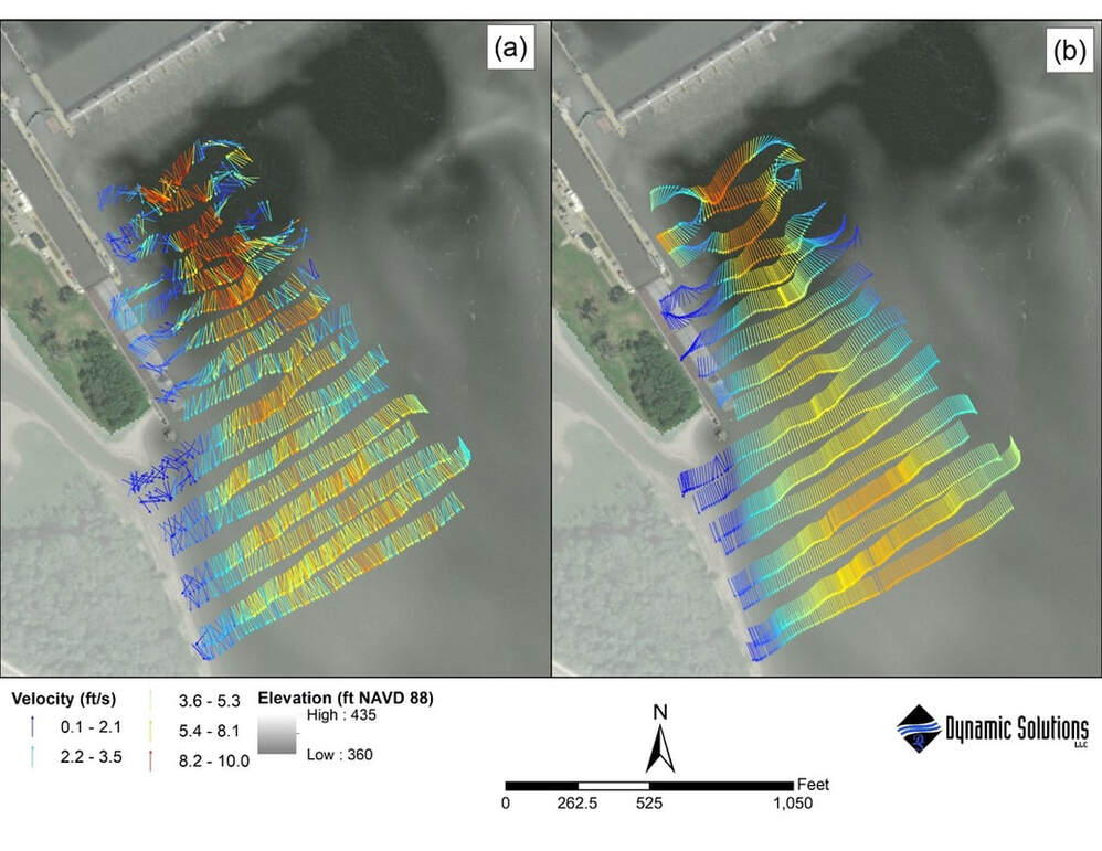
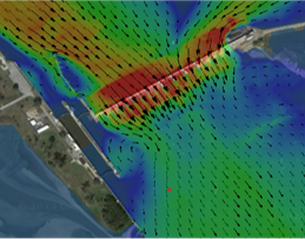
The lock and dam system on the Upper Mississippi River is one of the most prominent inland navigation systems in the world. DSLLC developed a high-resolution 2-D hydrodynamic model of the Mississippi River at Lock and Dam 25 with the Adaptive Hydraulics Model (AdH) to support design and construction of a lock expansion. The dam includes fourteen 60-ft wide Tainter gates and three 120-ft wide roller gates, requiring a model with maximum flexibility to simulate the range of annual gate operations. The hydrodynamic model was capable matching measured velocity magnitude and direction with high accuracy upstream and downstream of the dam across a wide range of flow conditions and gate operations. Simulated hydrodynamics will provide critical information to support design configuration and construction sequencing.
The lock and dam system on the Upper Mississippi River is one of the most prominent inland navigation systems in the world. DSLLC developed a high-resolution 2-D hydrodynamic model of the Mississippi River at Lock and Dam 25 with the Adaptive Hydraulics Model (AdH) to support design and construction of a lock expansion. The dam includes fourteen 60-ft wide Tainter gates and three 120-ft wide roller gates, requiring a model with maximum flexibility to simulate the range of annual gate operations. The hydrodynamic model was capable matching measured velocity magnitude and direction with high accuracy upstream and downstream of the dam across a wide range of flow conditions and gate operations. Simulated hydrodynamics will provide critical information to support design configuration and construction sequencing.
Artesian Slough Hydraulic Model and Closure Structure Design, California
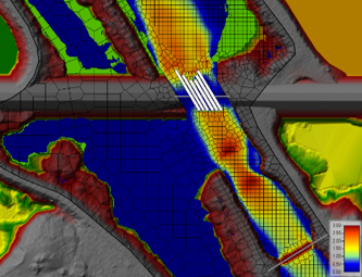
Hydraulic structure design must often serve multiple purposes and accommodate changing environmental conditions, such as sea level rise (SLR). DSLLC developed a HEC-RAS model and conceptual design of a water control structure on Artesian Slough to support the USACE South San Francisco Bay Shoreline Project. The structure allows for efficient discharge of wastewater effluent with an option for closure during high water events. Data analysis of coastal water level records informed SLR scenarios to provide tidal forcing for current conditions and a 50-year design horizon. Closure structure opening design was optimized for minimal head loss by running hundreds of 1-D HEC-RAS simulations of the structure. A complimentary 2-D HEC-RAS model provided detailed velocities in the channel.
Hydraulic structure design must often serve multiple purposes and accommodate changing environmental conditions, such as sea level rise (SLR). DSLLC developed a HEC-RAS model and conceptual design of a water control structure on Artesian Slough to support the USACE South San Francisco Bay Shoreline Project. The structure allows for efficient discharge of wastewater effluent with an option for closure during high water events. Data analysis of coastal water level records informed SLR scenarios to provide tidal forcing for current conditions and a 50-year design horizon. Closure structure opening design was optimized for minimal head loss by running hundreds of 1-D HEC-RAS simulations of the structure. A complimentary 2-D HEC-RAS model provided detailed velocities in the channel.
Observed (a) and simulated (b) velocity vectors in the flow jet downstream of Lock and Dam 25 on May 19, 2020 at 206,000 cfs. Velocities were simulated with a high-resolution 2-D hydrodynamic model using the USACE ERDC CHL’s Adaptive Hydraulics Model (AdH) software.
SEDIMENT TRANSPORT MODELING 2023
Mississippi River – Winchester Bend Sedimentation
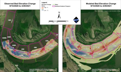
The USACE tasked DSLLC to investigate shoaling issues in the Donaldson Point Dike Field. DSLLC developed a 2-D AdH hydrodynamic and sediment transport model from Hickman, KY to Tiptonville, TN. A shear stress analysis, based on results from the hydrodynamic model, identified a zone in Winchester Bend which experiences relatively low bed shear stresses at moderate and high flows and relatively high shear stress at low flow. A novel application of the bed shear stress modifier to simulate local scour around the dikes significantly improved the simulation of bed morphology in the dike field and, consequently, in the navigation channel. Sediment transport model results were in agreement with the conceptual model and observed erosion and deposition volumes.
The USACE tasked DSLLC to investigate shoaling issues in the Donaldson Point Dike Field. DSLLC developed a 2-D AdH hydrodynamic and sediment transport model from Hickman, KY to Tiptonville, TN. A shear stress analysis, based on results from the hydrodynamic model, identified a zone in Winchester Bend which experiences relatively low bed shear stresses at moderate and high flows and relatively high shear stress at low flow. A novel application of the bed shear stress modifier to simulate local scour around the dikes significantly improved the simulation of bed morphology in the dike field and, consequently, in the navigation channel. Sediment transport model results were in agreement with the conceptual model and observed erosion and deposition volumes.
Mississippi River – Mosenthein Island Restoration
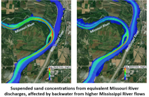
DSLLC developed and calibrated a 2-D AdH hydrodynamic and sediment transport model of the Mississippi River through St. Louis to simulate side-channel restoration alternatives. The model was calibrated to monthly sediment volume changes and SSC data observed in 2015. The model provides understanding of key sedimentation processes in the reach, particularly the considerable difference in suspended sediment loads between the Mississippi and Missouri Rivers. This leads to significant lateral variation in sediment concentrations, affecting restoration and nature-based design strategies.
DSLLC developed and calibrated a 2-D AdH hydrodynamic and sediment transport model of the Mississippi River through St. Louis to simulate side-channel restoration alternatives. The model was calibrated to monthly sediment volume changes and SSC data observed in 2015. The model provides understanding of key sedimentation processes in the reach, particularly the considerable difference in suspended sediment loads between the Mississippi and Missouri Rivers. This leads to significant lateral variation in sediment concentrations, affecting restoration and nature-based design strategies.
Arkansas River – Pool 10 Navigation
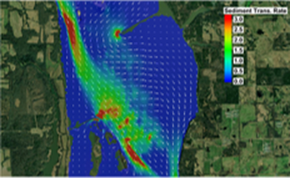
Sediment transport modeling studies can be data and budget intensive. However, sedimentation studies don’t always require comprehensive numerical sediment modeling for initial assessments. For a USACE study on the Arkansas River, we leveraged 2D hydrodynamic model results to provide estimates of sediment transport capacity through a reach which experiences recurring shoaling and evaluated the capacity-supply ratio. This analysis allowed us to efficiently screen alternative designs for navigation improvements.
Sediment transport modeling studies can be data and budget intensive. However, sedimentation studies don’t always require comprehensive numerical sediment modeling for initial assessments. For a USACE study on the Arkansas River, we leveraged 2D hydrodynamic model results to provide estimates of sediment transport capacity through a reach which experiences recurring shoaling and evaluated the capacity-supply ratio. This analysis allowed us to efficiently screen alternative designs for navigation improvements.
RISK AND UNCERTAINTY ANALYSIS
Dogtooth Bend of the Mississippi River Modeling and Risk Informed Design
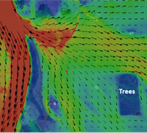
The Mississippi River risks a channel cutoff following a levee breach on the Dogtooth Bend Peninsula. DSLLC conducted a geomorphic analysis and developed a hydrodynamic and sediment transport model of the Mississippi River from Thebes to Cairo to quantify system dynamics. Following on that effort, we are supporting the USACE’s Risk-Informed Design (RID) which aims to estimate the risk of channel cutoff formation and identify measures which will reduce the risk. The RID is a process the USACE uses to make critical decisions in the face of substantial uncertainty. DSLLC staff are participating in RID panel discussions with USACE experts, supplying analyses on Dogtooth Bend hydrodynamics and geomorphic process, and providing input on the elicitation of failure probability estimates.
The Mississippi River risks a channel cutoff following a levee breach on the Dogtooth Bend Peninsula. DSLLC conducted a geomorphic analysis and developed a hydrodynamic and sediment transport model of the Mississippi River from Thebes to Cairo to quantify system dynamics. Following on that effort, we are supporting the USACE’s Risk-Informed Design (RID) which aims to estimate the risk of channel cutoff formation and identify measures which will reduce the risk. The RID is a process the USACE uses to make critical decisions in the face of substantial uncertainty. DSLLC staff are participating in RID panel discussions with USACE experts, supplying analyses on Dogtooth Bend hydrodynamics and geomorphic process, and providing input on the elicitation of failure probability estimates.
Probabilistic Floodplain Mapping
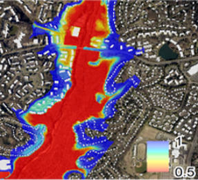
Probabilistic floodplain maps provide valuable information and can serve as a risk-informed decision making tool that transparently communicates model uncertainty. Whereas deterministic floodplain maps convey precisely known estimates of flood hazards, neglecting inherent uncertainties and potentially underestimating flood risk. Dynamic Solutions staff have developed and implemented a novel framework for generating probabilistic floodplain maps through Monte-Carlo simulations of flood hydraulics with HEC-RAS. Monte-Carlo simulations represent uncertainty in geomorphic adjustment, flood magnitude, and roughness parameters. This framework can be integrated into risk and uncertainty analysis as a quantitative and strategic decision making tool.
Probabilistic floodplain maps provide valuable information and can serve as a risk-informed decision making tool that transparently communicates model uncertainty. Whereas deterministic floodplain maps convey precisely known estimates of flood hazards, neglecting inherent uncertainties and potentially underestimating flood risk. Dynamic Solutions staff have developed and implemented a novel framework for generating probabilistic floodplain maps through Monte-Carlo simulations of flood hydraulics with HEC-RAS. Monte-Carlo simulations represent uncertainty in geomorphic adjustment, flood magnitude, and roughness parameters. This framework can be integrated into risk and uncertainty analysis as a quantitative and strategic decision making tool.
Incorporating Uncertainty and Nonstationarity into Flood Protection Reliability
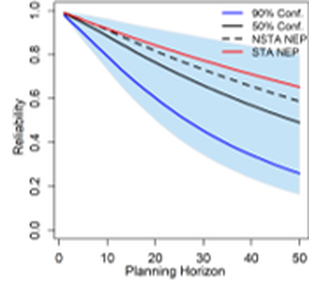
Water resources engineering projects are often designed to achieve a desired reliability over a planning horizon. However, traditional estimates of flood protection reliability are challenged by uncertainty and nonstationarity such as increases in hydrologic loading and changes in the flow capacity of floodplains. DSLLC has implemented novel techniques for quantifying flood protection reliability that account for these inherent uncertainties. Rather than a single value for reliability, the distribution of reliability may be quantified considering uncertainties. This enables a contextually appropriate valuation of risk. Including nonstationary flood frequency analysis and floodplain flow capacity enables reliability estimates that account for projected changes over the planning horizon. DSLLC staff have published peer-reviewed literature and provided training to academic institutions on tools that quantify integrated uncertainty and nonstationarity in reliability estimates.
Water resources engineering projects are often designed to achieve a desired reliability over a planning horizon. However, traditional estimates of flood protection reliability are challenged by uncertainty and nonstationarity such as increases in hydrologic loading and changes in the flow capacity of floodplains. DSLLC has implemented novel techniques for quantifying flood protection reliability that account for these inherent uncertainties. Rather than a single value for reliability, the distribution of reliability may be quantified considering uncertainties. This enables a contextually appropriate valuation of risk. Including nonstationary flood frequency analysis and floodplain flow capacity enables reliability estimates that account for projected changes over the planning horizon. DSLLC staff have published peer-reviewed literature and provided training to academic institutions on tools that quantify integrated uncertainty and nonstationarity in reliability estimates.
Relevant References:
Gaines, R. A., Sanborn, S. C., McAnally, W. H., & Wallen, C. M. (2021). Mississippi River Adaptive Hydraulics model development and evaluation, commerce to New Madrid, Missouri, reach. MRG&P Report (Mississippi River Geomorphology and Potamology Program (U.S.)) ; no. MRG&P Report No. 35
Stephens, T. A., & Bledsoe, B. P. (2023). Flood Protection Reliability: The Impact of Uncertainty and Nonstationarity. Water Resources Research, 59(2), e2021WR031921.
Stephens, T., & Bledsoe, B. (2022). Simplified Uncertainty Bounding: An Approach for Estimating Flood Hazard Uncertainty. Water, 14(10), 1618.
Stephens, T.A., B.P. Bledsoe. 2020. Probabilistic mapping of flood hazards: depicting uncertainty in discharge, land use, and geomorphic adjustment. Anthropocene. https://doi.org/10.1016/j.ancene.2019.100231
ABOUT DYNAMIC SOLUTIONS, LLC
Clean water sustains our world and healthy ecosystems enrich our lives. We believe today’s diverse and complex water resource issues demand cutting-edge solutions. Founded in 1996, DSLLC employs an expert staff of engineers, scientists, and modelers who excel at using the best science to solve the toughest problems.
Clean water sustains our world and healthy ecosystems enrich our lives. We believe today’s diverse and complex water resource issues demand cutting-edge solutions. Founded in 1996, DSLLC employs an expert staff of engineers, scientists, and modelers who excel at using the best science to solve the toughest problems.

