APPLIED RESEARCH
Monolithic Multiphysics Simulation of Compound Flooding During Hurricane Harvey with the Adaptive Hydraulics Model – Houston, TX
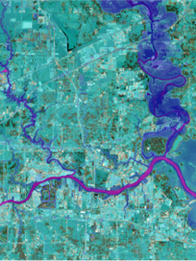
Dynamic Solutions was tasked by the USACE ERDC Coastal and Hydraulics Laboratory (CHL) to conduct a monolithic simulation of compound flooding during Hurricane Harvey using a novel version of the Adaptive Hydraulics Model (AdH). The advanced capabilities of AdH enables implementing spherical coordinates for basin-scale surge modeling, solving the 2-D shallow water equations for channel routing, utilizing the 2D diffusive wave equations for overland flow, and the simulation of rain-on-grid. This allowed us to conduct one of the first fully-coupled simulations of compound flooding due to the interaction of pluvial, fluvial, and storm surge driven flooding. The model encompassed Galveston Bay and the vast majority of Harris County, TX; this fully contained the multiple flood sources contributing to compound flooding. Simulated water levels were validated to more than 137 gaging stations, with 80% of peak water levels within 1-m of observed. Findings of this research contribute to the understanding and relative contributions of multiple flood sources as they interact to produce compound flooding. The methods and results were published in ASCE’s Journal of Hydraulic Engineering.
Dynamic Solutions was tasked by the USACE ERDC Coastal and Hydraulics Laboratory (CHL) to conduct a monolithic simulation of compound flooding during Hurricane Harvey using a novel version of the Adaptive Hydraulics Model (AdH). The advanced capabilities of AdH enables implementing spherical coordinates for basin-scale surge modeling, solving the 2-D shallow water equations for channel routing, utilizing the 2D diffusive wave equations for overland flow, and the simulation of rain-on-grid. This allowed us to conduct one of the first fully-coupled simulations of compound flooding due to the interaction of pluvial, fluvial, and storm surge driven flooding. The model encompassed Galveston Bay and the vast majority of Harris County, TX; this fully contained the multiple flood sources contributing to compound flooding. Simulated water levels were validated to more than 137 gaging stations, with 80% of peak water levels within 1-m of observed. Findings of this research contribute to the understanding and relative contributions of multiple flood sources as they interact to produce compound flooding. The methods and results were published in ASCE’s Journal of Hydraulic Engineering.
Assessing the Interaction of Riverine Flood Flows and Coastal Storm Surge During Hurricane Barry – Coastal Louisiana
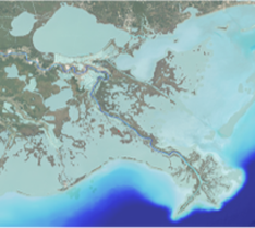
Compound flooding is projected to increase in magnitude and frequency - impacting coastal areas, communities, and socio-economic hubs around the globe. DSLLC was tasked by the USACE ERDC- CHL to investigate the interaction of Mississippi River flood flows and coastal storm surge on water levels. To do so we are applying an advanced version of the AdH to develop a 2-D hydrodynamic model of the entire Atlantic and Gulf Coasts and the Mississippi River from the Birdsfoot Delta to Simmesport, LA. This allows for simulation of the complex physics of interacting flood sources within a domain that fully encompasses the compound flooding transition zone
Compound flooding is projected to increase in magnitude and frequency - impacting coastal areas, communities, and socio-economic hubs around the globe. DSLLC was tasked by the USACE ERDC- CHL to investigate the interaction of Mississippi River flood flows and coastal storm surge on water levels. To do so we are applying an advanced version of the AdH to develop a 2-D hydrodynamic model of the entire Atlantic and Gulf Coasts and the Mississippi River from the Birdsfoot Delta to Simmesport, LA. This allows for simulation of the complex physics of interacting flood sources within a domain that fully encompasses the compound flooding transition zone
Oyster Larval Transport and Metapopulation Modeling – Coastal Louisiana
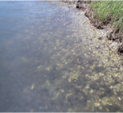
The eastern oyster occupies a vital ecological role and provides numerous ecosystem services in estuaries along the Louisiana Coast and the northern Gulf of Mexico. However, decision making and restoration efforts to mitigate declining oyster populations lack understanding and evidence for strategic resource allocation. DSLLC is leading an oyster metapopulation modeling effort with Federal, state, academic, and local partners to gain a better understanding of oyster population dynamics supporting decision making and coastal Louisiana. This effort includes novel linkages of 3-D ocean circulation and water quality models, oyster larval transport models, and on-reef population dynamics to simulate recruitment success and mortality throughout the eastern oyster life cycle for existing and foreseeable future conditions.
Oyster Larval Transport and Metapopulation Modeling – Coastal Louisiana
The eastern oyster occupies a vital ecological role and provides numerous ecosystem services in estuaries along the Louisiana Coast and the northern Gulf of Mexico. However, decision making and restoration efforts to mitigate declining oyster populations lack understanding and evidence for strategic resource allocation. DSLLC is leading an oyster metapopulation modeling effort with Federal, state, academic, and local partners to gain a better understanding of oyster population dynamics supporting decision making and coastal Louisiana. This effort includes novel linkages of 3-D ocean circulation and water quality models, oyster larval transport models, and on-reef population dynamics to simulate recruitment success and mortality throughout the eastern oyster life cycle for existing and foreseeable future conditions.
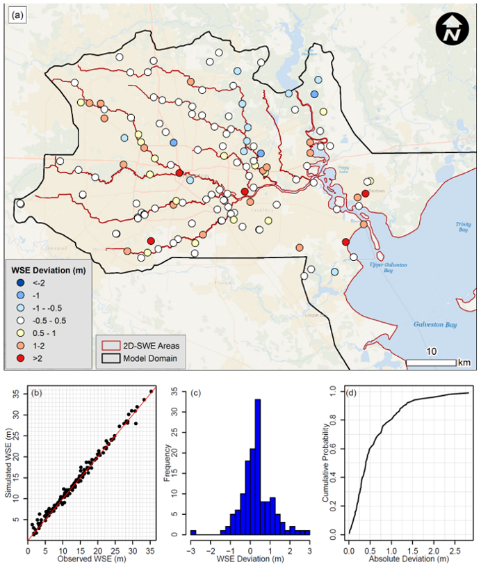
Simulated peak water surface elevations compared to surveyed high water marks during Hurricane Harvey: (a) deviations shown spatially; (b) plotted relative to a 1∶1 line; (c) distribution of deviations; and (d) cumulative distribution of absolute deviations. (Sources: Esri, GEBCO, NOAA, National Geographic, DeLorme, HERE, Geonames.org, and other contributors.) Note: The range of uncertainty in surveyed high water marks is up to +/- 0.5 m.
Relevant References:
Stephens, T. A., Savant, G., Sanborn, S. C., Wallen, C. M., & Roy, S. (2022). Monolithic multiphysics simulation of compound flooding. Journal of Hydraulic Engineering, 148(9), 05022003.
La Peyre, M. K., Marshall, D. A., & Sable, S. E. (2021). Oyster model inventory: Identifying critical data and modeling approaches to support restoration of oyster reefs in coastal US Gulf of Mexico waters (No. 2021-1063). US Geological Survey.
ABOUT DYNAMIC SOLUTIONS, LLC
Clean water sustains our world and healthy ecosystems enrich our lives. We believe today’s diverse and complex water resource issues demand cutting-edge solutions. Founded in 1996, DSLLC employs an expert staff of engineers, scientists, and modelers who excel at using the best science to solve the toughest problems.