Perdido Bay HSPF/EFDC
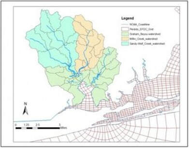
Perdido Bay, located west of Pensacola, FL in the Northern Gulf of Mexico, was included on Florida’s 2004 303(d) list of impaired water bodies because of nutrient enrichment and oxygen depletion. Perdido Bay is characterized by freshwater inflow from the Perdido River basin, nutrient loading from an industrial wastewater discharge, stratification, hypoxia and exchange with the Gulf of Mexico through Perdido Pass. Dynamic Solutions developed a linkage of streamflow and pollutant loading from a watershed model (HSPF) for input to a 3-D EFDC hydrodynamic, sediment transport, and water quality model model of Perdido Bay. The Florida Department of Environmental Protection used the watershed-water quality model to support water quality management planning efforts for Perdido Bay.
The HSPF model was used to simulate streamflows and nutrient loads for input to the hydrodynamic and water quality model and to represent land uses and related mass loading outputs with different jurisdictional boundaries and sub-watersheds. Existing BMPs in sub-watersheds and jurisdictional boundaries were represented in the HSPF model to account for pollutant removal efficiencies of BMPs. HSPF model results were summarized as tables of seasonal mass load budgets for nutrients with load data compiled by land use and cover, sub-watersheds, and jurisdictional boundaries.
The EFDC model accounted for temporally and spatially dynamic tidal hydrodynamics (flow, salinity, temperature), sediment transport, water quality and eutrophication processes, sediment oxygen demand, and benthic flux of nutrients across the sediment-water interface. The EFDC model was validated to historical field data collected in 1993, 1994, and 1999. Dynamic Solutions provided training to Florida DEP staff in the watershed and Perdido Bay water quality models.
Return to the EFDC page