Cole’s Bayou

Dynamic Solutions staff is providing technical modeling and project management support for the Cole’s Bayou Marsh Restoration Project. The specific goals of the project are to restore 365 acres of brackish marsh and supply nutrients and additional freshwater to 53 acres of existing marsh by increasing freshwater flows and sediment supplies to the interior of the marsh by enhancing the hydraulic connections.
Dynamic Solutions gathered existing bathymetry/topography, water level, salinity, and total suspended solids data available near the project area. The data was evaluated and gaps in the data were identified. A data collection program was designed to gather the additional bathymetric/topographic, water level, salinity, TSS, and nutrient data necessary, within budgetary constraints, to setup and calibrate a robust hydrodynamic model of the coastal marsh restoration site. Thinking ahead to model development was critical, as several sites were necessary to establish appropriate boundary conditions for the model. Well positioned and accurate boundary condition data is essential creating an efficient and robust model. Additionally, a host of hydrodynamic modeling tools were evaluated and DSLLC staff selected the appropriate tool to accurately and efficiently simulate the conditions in the project area for future with project (FWP) scenarios and future without project (FWOP) conditions.
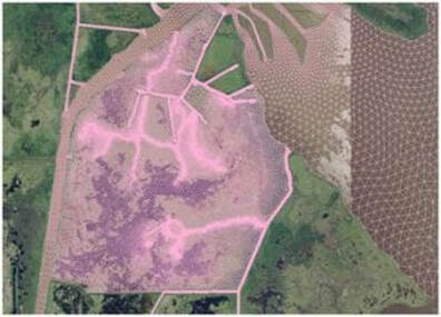
The 2-D hydrodynamic ADH model was chosen and the data collection program is nearing completion. DSLLC modeling staff traveled to the Cole’s Bayou coastal marsh to perform reconnaissance and evaluate site conditions. Staff merged publicly available bathymetric data with project survey data and developed a model mesh for Cole’s Bayou, Vermilion Bay, and Little Vermilion Bay. Water levels and salinity trends at the model boundaries and within the domain were evaluated. Staff have completed initial large-scale calibration are fine-tuning model calibration to meet an acceptable level of accuracy. Root-mean-square error (RMSE) and relative-RMSE statistics will be evaluated at each calibration station. Dynamic Solutions will then use the calibrated the model for scenario analysis (potentially 5-8) of dredging and hydraulic structure operations to produce the information needed for design of the project features and ascertain of environmental impacts of the site alterations.
Return to the ADH Page
